Sky Tracker Universal Planisphere
An innovative astronomical instrument uniting a transparent circular star chart overlay with a stereographic Earth map, providing universal night sky observation from any geographical latitude and longitude on the planet[cite: 7].
The Instrument
Concentric Dual-Disc Architecture
Features a transparent celestial constellation disc coupled at the center pivot to a stereographic polar Earth projection map, allowing smooth, continuous 360° rotation[cite: 7].
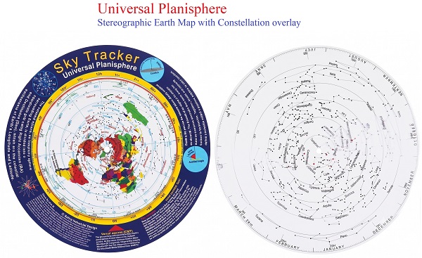
Truly Universal Coverage
Overcomes the single-latitude limitation of traditional planispheres by calibrating the entire terrestrial globe directly against the celestial sphere[cite: 7].
Core Mechanics
Complete global projection displaying terrestrial longitude lines and geographical continents radiating outward from the polar center[cite: 7].
High-contrast celestial chart indexing stellar asterisms, major deep-sky targets, and calibrated Right Ascension hours (0h to 24h)[cite: 7].
Graduated calendar months and sidereal tracking indices positioned along the disc perimeter for date-specific night-sky synchronization[cite: 7].
Allows astronomers in any city or hemisphere to quickly align their exact longitude and capture their local zenith and horizon sky view[cite: 7].
Setup & Observation
Alignment Reference Matrix
| Layer | Reference Grid | Functional Role |
|---|---|---|
| Upper Disc | Right Ascension (0h–24h)[cite: 7] | Constellation Overlay[cite: 7] |
| Base Disc | Earth Longitude & Latitude[cite: 7] | Stereographic Geography[cite: 7] |
| Outer Ring | Annual Calendar Months[cite: 7] | Sidereal Date Lock |
| Center Pivot | Polar Axis | Universal 360° Rotation[cite: 7] |
1. Locate your observer longitude on the stereographic base map[cite: 7].
2. Rotate the transparent star chart to align local sidereal time or the target Right Ascension hour with your longitude line[cite: 7].
3. Read the constellation overlay directly above your region to see the night sky currently at your local zenith[cite: 7].